- Geomorphologists identify landforms, sometimes, by strange names.Some of these names are from colloquial uses, while others have disputed origins. Inselbergs, mesas, spits and beach ridges are some examples.These eventually awkward terms, however, convey relevant information about the geometry, composition and genetic processes associated with the landforms to which they refer.It is also convenient to consider that landforms compose the basis upon which many forms of life (including human) are territorially organized all over the planet.
- Moreover, if geomorphologic terms are used to identify the occurrence of a landform along a part of the earth surface, as is the case in maps, they are defining, for each area identified, an isotropic condition that can be used as a territorial basis for the computation of any variability of environmental characteristics which occur over that same portion of the earth's surface. This possibility of use of the geomorphologic classification, obviously valid as a investigative procedure for the categories of any thematic map, is particularly interesting for biodiversity, since basic environmental information (geometry, composition and origin) is automatically contained in the names of the identified landforms.
- Before disregarding the above considerations as not concerned to GIS and Geoprocessing, some attention can be given to the computational effort needed to identify the environmental diversity associated to each of the landforms composing a geomorphologic map. In effect, to measure the geodiversity of an area consists, essentially, in executing a careful territorial inventory of its prevailing physical, biotic and socio-economical characteristics. This aim requires the existence of a comprehensive environmental database, upon which the mentioned inventory is to be executed. In this regard, the methodological procedure to be used has been named VAIL (Varredura e Integração Locacional, in Portuguese - Scanning and Locational Integration) by Xavier-da-Silva, 2001, and can be used for this purpose of geodiversity investigation as well as for many other procedures of environmental information extraction. This procedure is part of the new semiotics stemming from the massive use of computational resources in environmental investigation (Bonham-Carter, 1996; Xavier-da-Silva, 2001). As a chapter of a book on biodiversity (Garay, 2001) some indicators, named Geodiversity Indexes, have been created (Xavier-da-Silva et alli, 2001a, in Garay, 2001). The present paper reports the use of these indexes in a coastal area near Rio de Janeiro, Brazil, specifically a very sensitive and preserved barrier beach complex named Restinga da Marambaia.As a background for this application, some concepts are discussed.
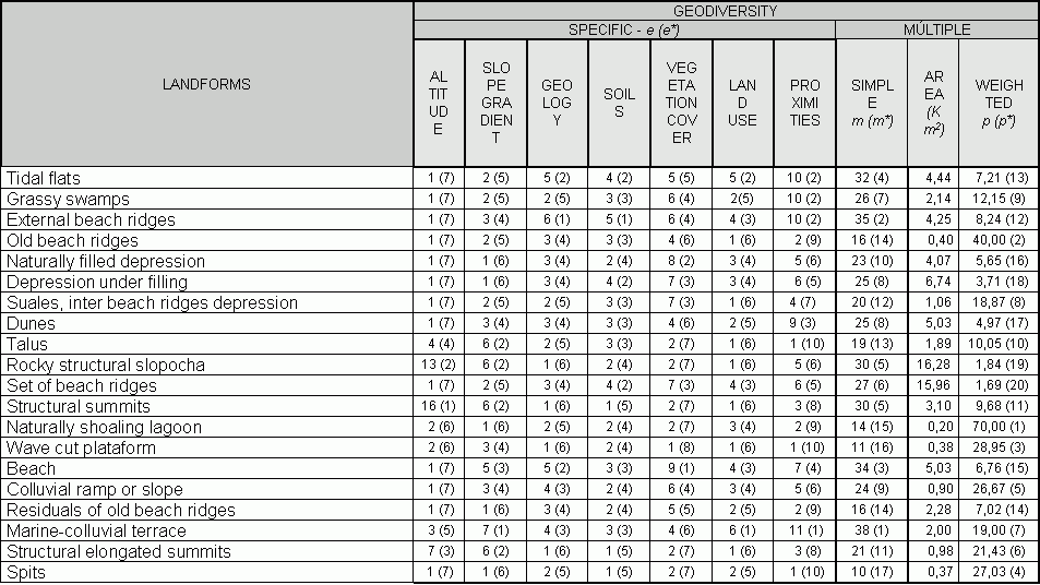
FIGURE 1 - Click for larger view
Geodiversity is a concept which can be grasped if the environment is considered as the locus of a convergence of causing factors. It is the assemblage of environmental characteristics incident over a particular place.Being axiomatically unique, it can be operationally identified through the use of a digital model of that place (Xavier-da-Silva, 1982). This model (as any model), being a simplification of the reality, must encompass the environmental aspects relevant to the investigation under realization.
Another conceptual aspect deserving attention is the assumption that the biodiversity found in a certain environment is directly associated to its geodiversity. This postulate, which apparently pervades this paper, actually needs to be verified as to the intensity and singularities of the postulated direct association. In this regard, the application of the present or similar indexes can document the presence and degree of this relationship between the overall characteristics of a specific environment - geodiversity - and the variability of its biological components, i.e.its biodiversity.
From the above delineated connection between the concept of geodiversity and the digital model of the environment, which allows the creation of its representative parameters, it follows that some simple geoprocessing techniques can be used to exhaustively measure the geodiversity existing over any area. The results computed over the set of thematic maps (a digital database) can be presented as a table of easy reading (fig. 1). Through the inspection of its rows and columns relevant information can be obtained. This information can assume several formats, some specific, some generalized. The geodiversity indicators presented in the table of fig.1 are representative of these informational formats. They received denominations believed to be clearly related to their logical content. A systematic presentation of these indicators, to be accompanied by the observation of the table of fig.1, is made in the following paragraphs.
A - Indexes of Specific Diversity "e " and Specific Diversity Rank ("e*")
The first of these indicators, "e", presents, for each thematic map, the amount of its categories found in each of the classes of the map used as a basis for computation (classes of landforms, in the table of fig.1). This is the particular diversity of each thematic map found in association with a specific landform. The Specific Diversity Rank ("e*"), namely indicates the ordinal position of the previous index in relation to all other considered classes of landforms.
The two indexes defined above allow comparisons between their values and also along their respective columns, in which are registered the variability of the considered parameter (see the values for Altitude, in fig.1) in terms of number of categories and respective ranks. It can be seen, for example, that the seventh rank was found for thirteen types of landforms, a validating result totally expected for a low lying coastal area such as the Restinga da Marambaia (see fig.2).
Non-parametric rank correlation coefficients can be calculated using the values of the rank indexes obtained for each thematic map. These correlations would indicate, to some extent, the degree of independence (or dependence) existing among the parameters chosen for the analysis of the local geodiversity.
B - Indexes of Simple Multiple Geodiversity "m" and Simple Multiple Diversity Rank ("m*")
These indexes are named "simple" because they are non weighted and directly obtained through the sum along the lines of the table of fig. 1. For example, the number 32 found in the eight column of the mentioned table, represents the sum of the classes of each of the seven environmental parameters considered in the performed analysis. It is accompanied by the number (4), which indicates that, in terms of the simple multiple diversity rank, the landform "tidal shoals" was ranked in the fourth place.
Both indexes immediately above are direct indicators of Geodiversity. Their values may be used for direct comparisons among different results obtained for different areas, but they can be used, basically, to build the next indexes, presented below.
C - Indexes of Weighted Multiple Diversity "p" and Weighted Multiple Diversity Rank ("p*")
If data concerning the areas occupied by each of the landforms are made available (column 9 of the table of fig.1), the geodiversity can be expressed through a ratio between the number of classes registered in the simple multiple geodiversity index and the area of the respective landform. This is a measure of the density of the environmental diversity found in association with each landform and the composite index thus generated can also be ranked. The ratio is the Weighted Multiple Diversity Index "p", and its respective relative position regarding the values associated to the other landforms is the Weighted Multiple Diversity Rank ("p*").
The main importance of these last indexes is to permit comparisons among
different results obtained from different areas. It also obvious
that the index "p" can identify areas of great interest, such as small
territorial units with great geodiversity. For this type of geographic
areas it is expected a great interaction among all the forms of life, generating,
in principle, greater biodiversity than the one expected over large areas
with the same amount of environmental variability, that is, having
smaller density of variability. Selection of areas deserving strict
protection against misuses can be based on this type of quantified identification,
and rules of environmental management can be devised on the basis of extensive
tabulation of values and possibilities of correlations contained in this
type of environmental inventory.
REFERENCES
- ARONOFF, S.(1991).Geographic Information Systems: a management perspective. Ottawa: WDL, 298 p.
- BONHAM-CARTER, G.F.(1996).Geographic Information Systems for geoscientists. Ontario: Pergamon, 400 p.
- CHRISTOFOLETTI, A.(1999).Modelagem de sistemas ambientais.São Paulo:Edgard Blücher, 200 p.
- GARAY, I.and DIAS, B.F.S. (2001) Conservação da biodiversidade em ecossistemas tropicais - Petropolis - Editora Vozes - 432 p.
- GOES, M.H.B.e outros (2000).Um modelo digital para a restinga e paleoilha da Marambaia (RJ) para fins militares, investigação científica e ecoturismo controlado.Rio de Janeiro: LGA/UFRJ, no prelo.
- XAVIER-DA-SILVA, J.(1982).A digital model of the environment, na effective approach to areal analysis. Anais do International Geographic Studies. Rio de Janeiro: UGI/UFRJ, p.17-22.
- XAVIER-DA-SILVA, J.(1994).Geomorfologia: uma atualização de bases e conceitos. Geomorfologia/Sandra Baptista Cunha e Antônio José Teixeira Guerra, organizadores. Rio de Janeiro: Bertrand Brasil, p.393-414.
- XAVIER-DA-SILVA, J.(2000).Geomorfologia, Análise Ambiental e Geoprocessamento. Revista Brasileira de Geomorfologia. Uberlândia: UGB/UFU, volume 1 (1) p.48-58.
- XAVIER-DA-SILVA, J.e CARVALHO-FILHO, L.M.(1993).Sistemas de Informação Geográfica: uma proposta metodologica. Anais da IV Conferência Latinoamericana sobre Sistemas de Informação Geográfica/2o Simposio Brasileiro de Geoprocessamento. São Paulo: EDUSP, p.609-628.
- XAVIER-DA-SILVA, J.; ALMEIDA, L.F.B.e CARVALHO-FILHO, L.M.(1996).Geomorofologia e Geoprocessamento.Geomorfologia, técnicas e aplicações/Sandra Baptista Cunha e Antônio José Teixeira Guerra, organizadores. Rio de Janeiro: Bertrand Brasil, p.283-309.
- XAVIER-DA-SILVA, J.; PERSSON, V.G.; LORINI, M.L.; BERGAMO, R.B.A.; RIBEIRO, M.R.; COSTA, AJ.S.T.; IERVOLINO, P.; ABDO, O.E. (2001a).Índices de Geodiversidade: aplicação de SGI em estudos de biodiversidade. Conservação da biodiversidade em ecossistemas tropicais/Irene Garay e B.Dias, organizadores. Rio de Janeiro: Vozes, 299-316
- XAVIER-DA-SILVA, J. (2001b) Geoprocessamento para análise ambiental - Rio de Janeiro - Edição do autor - 228 p
Authors
Jorge Xavier-da-Silva, Ph.D.1
mailto:xavier@lageop.ufrj.br
Luiz Mendes de Carvalho-Filho, M.Sc.2
mendes@ufrj.br