| GIS RESPONSE TO INDONESIAN TSUNAMI |
The
nature of our "horizontal technology" requires us to participate in
planning for, response to, and mitigation of disasters, both man-made
and natural.We have been tracking websites
offering spatial information and mapping resources related to the
tsunami
disaster.Here are several we have found.Please do not hesitate to contact us with
additional resources
you are aware of, as we would like to maintain this list.
| Want
to Help? - Here Is a List of Relief Organizations Working in the
Disaster Area |
 USAID -- HOW YOU CAN DONATE. USAID -- HOW YOU CAN DONATE.
If you are in a position
to
assist monetarily and have not already done so,
click the link
for a listing of more than 70 non-profit agencies working to provide
assistance to
people affected by the earthquake and tsunamis.You may donate money to
them by mail, phone, or through their web sites,
which are linked
below.This
link will take you to USAID's page describing how you can help.
WHO WE ARE: USAID is the U.S.government agency responsible for
economic and humanitarian assistance around the world.As a U.S.
Federal government agency, we do not accept donations.However, we do
work together with many of the organizations below to provide U.S.
taxpayer assistance to the victims of the earthquake/tsunami.You may
contribute to any of the relief agencies below, all of whom are also
working with contributions from the general public....More
|
| Mapping
Technology Helps Direct Tsunami Aid Efforts |
 NPR - All
Things Considered (Audio) -- It's hard to know how many
people are affected when disasters like a tsunami strike remote areas.
But a new approach to population mapping called LandScan is improving
the ability of relief agencies to estimate how many people need help....
More NPR - All
Things Considered (Audio) -- It's hard to know how many
people are affected when disasters like a tsunami strike remote areas.
But a new approach to population mapping called LandScan is improving
the ability of relief agencies to estimate how many people need help....
More
|
| UN
Coordinates Relief to Survivors |
 United Nations
-- "Perhaps one of the
most devastating natural disasters ever;"
affecting at least seven countries, killing tens of thousands of people
and jeopardizing millions more.Jan Egeland, UN Emergency
Relief Coordinator...More United Nations
-- "Perhaps one of the
most devastating natural disasters ever;"
affecting at least seven countries, killing tens of thousands of people
and jeopardizing millions more.Jan Egeland, UN Emergency
Relief Coordinator...More
Click here
to look at the UN's map of the situation.
|
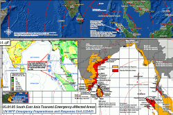
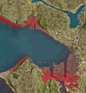
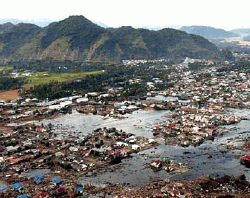
| South
Asia Earthquake and Tsunami Map - Affected Zones |
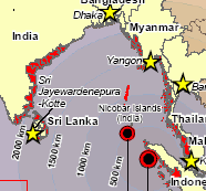 ReliefWeb
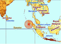
-- Earthquake and Tsunami - Situation map #4 - Massive
earthquake (M9.0) struck west coast of Indonesia's northern Sumatra
island on 26 Dec 2005.Second earthquake (M7.3) occurred in nearby
Nicobar Islands region (India).Quakes triggered tsunamis which may
have killed as many as 150,000 people (UN DSG - 31 Dec 2004). ReliefWeb
-- Earthquake and Tsunami - Situation map #4 - Massive
earthquake (M9.0) struck west coast of Indonesia's northern Sumatra
island on 26 Dec 2005.Second earthquake (M7.3) occurred in nearby
Nicobar Islands region (India).Quakes triggered tsunamis which may
have killed as many as 150,000 people (UN DSG - 31 Dec 2004).
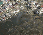
AFFECTED COUNTRIES India 7,330 reported deaths, 5,900 missing in
Nicobar Islands, 1,035 villages affected.(SITREP 7) Indonesia 80,248
reported deaths, 1,541 missing; more than 100,000 people living in
camps/temporary shelters.Maldives One third of population severely
affected (reliant on relief assistance for food, water); 12,200 people
registered as homeless, 8,500 (of 12,000) evacuated to other islands.
Sri Lanka 28,551 reported deaths, 889,175 displaced; 82,320 houses
destroyed; 12 of 25 districts severely affected.Worstaffected
districts: Jaffna, Mullativu, Trincomalee, Batticaloa, Ampara,
Hambantota, Matara, Galle.Thailand 4,798 reported deaths, 6,384
missing.Significantly higher death toll (estimates up to 11,000) now
being cited.Seychelles Extensive infrastructural devastation on
coastline areas in south and west of Mahe island, as well as Praslin
and La Digue islands.Flooding in capital (Victoria); severe damage to
commercial/fishing ports. ...More
|
UNOSAT Provides Satellite Imagery
|
 UNOSAT
-- UNOSAT is a UNITAR project by UNOPS.UNOSAT is hosted
at the European Organization for Partical Physics (CERN).It is funded
by the European Space Agency, the Centre Nacional pour les Etudes
Spatiales of France (CNES) and the Ministry of Foreign Affairs of
France ...More UNOSAT
-- UNOSAT is a UNITAR project by UNOPS.UNOSAT is hosted
at the European Organization for Partical Physics (CERN).It is funded
by the European Space Agency, the Centre Nacional pour les Etudes
Spatiales of France (CNES) and the Ministry of Foreign Affairs of
France ...More
|
Geospatial
One-Stop Portal Resources
|
 ESRI is creating an Indian
Ocean Disaster sub-channel on the Geospatial One-Stop portal to make a
variety
of resources available to anyone who needs them.These resources
include many
types of geographic data, map services, information about GIS projects
in the
region, lists of volunteers, and more...More ESRI is creating an Indian
Ocean Disaster sub-channel on the Geospatial One-Stop portal to make a
variety
of resources available to anyone who needs them.These resources
include many
types of geographic data, map services, information about GIS projects
in the
region, lists of volunteers, and more...More
|
| USAID
Disaster Assistance South and Southeast Asia Earthquake and Tsunamis |
| USAID
-- The USAID/DART in Sri Lanka, in coordination with OCHA, has
completed damage assessments of the Galle and Hambantota districts.In
both districts, the USAID/DART reported that although locally organized
distribution efforts are meeting the immediate needs of the affected
population, sufficient sanitation facilities and shelter materials are
the highest priorities, followed by the provision of water containers,
household items, and mosquito nets...More
|
| INTERNATIONAL
GOVERNMENT AID
RESPONSE |
|
Indian
Natural Hazard Map tracked Tsunami seven years ago |
| India
News:
Kolkata -- The possible epicentre of the killer Tsunami and
the probable path that the waves would take had been precisely tracked
on the Indian Natural Hazard Map seven years ago.Director of the
National Atlas and Thematic Mapping Organisation (NATMO) Dr G N Saha
told PTI here today that the map, made by NATMO in the late nineties,
had shown the possible epicentre in Indonesia and Tsunami waves
travelling to hit the Andaman and Nicobar Islands as well as the
southern Indian coast."Though this was no prediction of any sort, it
just showed theoretically what would happen if an earthquake ...
More
|
| Indian
Ocean Earthquake and Tsunamis |
 Washington
DC - USAID -- On January 3, President George W.Bush
announced a nationwide charitable giving effort.Former Presidents
George Bush and Bill Clinton will lead the fundraising drive, which
will ask American citizens to contribute directly to reliable charities
already providing assistance to the affected populations.U.S.
Secretary of State Colin Powell, Florida Governor Jeb Bush, and USAID
Administrator Andrew Natsios arrived in the region on January 3.On
January 4, the delegation will meet with U.S.military and Thai
government officials before traveling to Phuket.The same day, the
delegation will travel to Jakarta and possibly Northern Sumatra.On
January 6, Secretary Powell will attend the Association of Southeast
Asian Nations (ASEAN) Conference, an emergency summit to improve
coordination and work to overcome logistical constraints to the
humanitarian response.Following the conference, the U.S.delegation
plans to travel to Sri Lanka....More Washington
DC - USAID -- On January 3, President George W.Bush
announced a nationwide charitable giving effort.Former Presidents
George Bush and Bill Clinton will lead the fundraising drive, which
will ask American citizens to contribute directly to reliable charities
already providing assistance to the affected populations.U.S.
Secretary of State Colin Powell, Florida Governor Jeb Bush, and USAID
Administrator Andrew Natsios arrived in the region on January 3.On
January 4, the delegation will meet with U.S.military and Thai
government officials before traveling to Phuket.The same day, the
delegation will travel to Jakarta and possibly Northern Sumatra.On
January 6, Secretary Powell will attend the Association of Southeast
Asian Nations (ASEAN) Conference, an emergency summit to improve
coordination and work to overcome logistical constraints to the
humanitarian response.Following the conference, the U.S.delegation
plans to travel to Sri Lanka....More
|
| NGA
Assisting U.S.Agencies in Tsunami Disaster Assessment |
 NGA -- The
NGA is providing imagery products of the affected areas on a daily
basis to: the U.S.Agency for International Development's Office of
Foreign Disaster Assistance (OFDA); the U.S.Pacific Command (USPACOM),
in whose region the tsunami occurred and to other U.S.government
agencies supporting humanitarian relief activities....More NGA -- The
NGA is providing imagery products of the affected areas on a daily
basis to: the U.S.Agency for International Development's Office of
Foreign Disaster Assistance (OFDA); the U.S.Pacific Command (USPACOM),
in whose region the tsunami occurred and to other U.S.government
agencies supporting humanitarian relief activities....More
|
| PRIVATE COMPANY
RESOURCES |
| Resources
at ESRI's website |
 ESRI --
Ray Carnes, of ESRI Corporate Technical
Marketing, provided information about resources being maintained at
ESRI's website.This page offers a collection of links to map and data
resources relevant to the recent earthquake, tsunami, and disaster
recovery efforts in the Indian Ocean region...More ESRI --
Ray Carnes, of ESRI Corporate Technical
Marketing, provided information about resources being maintained at
ESRI's website.This page offers a collection of links to map and data
resources relevant to the recent earthquake, tsunami, and disaster
recovery efforts in the Indian Ocean region...More
Data for countries affected by the disaster can be found here.
|
|
 Washington
DC - NOAA --
Washington
DC - NOAA --  USGS
--
USGS
--  Department
of Defense -- ...
Department
of Defense -- ...