The whole world has gone map crazy, or so it seems. Even those of us
who habitually confuse longitude and latitude have turned geo gaga. Is
it something in the water? In fact, the typical spatial convert is
largely compos mentis: not mad about maps, so much, but rather
sensibly interested in information (conveyed primarily via text, images
and location) that relates to him. My own company, Schmap, is focused on the dynamic
integration of information with maps...
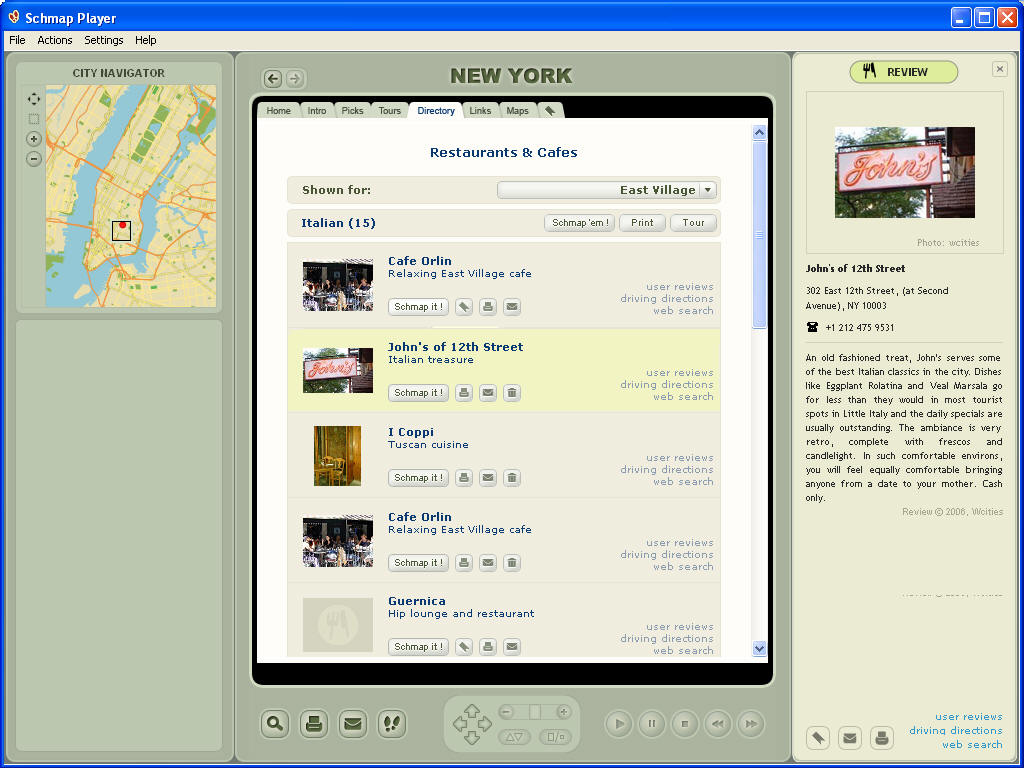
Consider this common scenario. I have a map and some information about
places – let's say Italian restaurants - that could be shown on this
map. I have an article talking about these restaurants, reviews and
photos for each, plus a directory of restaurant addresses. The
challenge here is that, even in this simplest of cases, there are many
ways that a reader might want to browse and use this information.
Some readers will find the article interesting, yet only certain restaurants will catch the eye sufficiently for them to want to see a detailed review. Some readers are more spatially inclined – they might prefer to browse the map, spotting restaurants that merit investigation. Others would like to view pictures and only read further should one of these suggest an ambience conducive to the type of dining experience they're after.
Another class of readers is pressed for time and would like to take a quick virtual tour of ‘must visit' eateries. Still others are data-driven and would want to see the restaurants listed, perhaps in order of price or Michelin rating. Then there are those interested only in restaurants that match certain criteria, such as offering disabled access or accepting a particular credit card.
One reader wants to email restaurant details to a friend; another needs driving directions; a helpful type wants to tell the writer he's made a mistake; a fourth wants to bookmark several restaurants for later reference. Another reader wants to print reviews and a map for a handful of restaurants in his neighborhood; an inquisitive one wants to research further (see what the dining public has to say on a website, perhaps); another wants to copy the addresses of three restaurants to her PDA. One hungry reader simply wants to head straight to the closest bistro and chow on down.
And so it goes on: one simple set of data, with countless ways to
browse and use it. How to manage and present this information in a
fashion that pleases all these folks is a basic question that drove
much of the development behind Schmap (as in ‘map, schmap' or ‘any
schmuck can schmap').
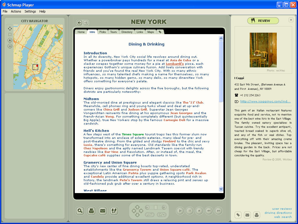
Our first stab at integration is called the Schmap Player. The basic concept is a small desktop app, one that stores map data client-side and uses the client processor to maximize performance. Specifically, we make the maps ‘light' (using a vector format developed for this purpose), so that a whole city can be comfortably cached in RAM, instantly viewable at any level of detail. Together with the client-side caching and indexing of images, text and addresses, this allows us not only to integrate data (as a website might do), but to mesh it dynamically in a variety of ways…
When I'm reading an article, for instance, I mouse over a place name, and an overview map shows me in real time where this is (a click takes me to a detailed map and another back to the text). Mousing over a place name in the text - or an icon on the map - is sufficient to display a review, plus a slideshow of photos. A list of places – museums, say - updates automatically as I pan around the map. Moving closer, new layers of detail come naturally and dynamically into view (rather than jumping into frame at the next available zoom stop); as I mouse over a road name, it automatically expands to improve readability.
Dynamic meshing aside, opting for a client-side component opens up a number of interesting possibilities, many of which would prove clumsy or unachievable with a browser/server solution. These include advanced custom print, local storage and editing of points of interest (for reference offline, and perhaps transfer to/from other applications), and the chance to collate or author map-related data in a controlled environment. The client-side app can then integrate seamlessly - via an Internet browser - with a vast and growing body of geospatial data on the Web, with limitless potential for useful interaction…
In Schmap's case, much of this functionality and integration is
development in progress. Right now, we demonstrate the basic
integration (maps, text, pictures, directory listings and some Internet
links) with a series of free,
downloadable travel guides, for destinations throughout the United
States and Europe (Canada, Australia and New Zealand available soon).
We've released 84 such Schmap Guides since launch in March and have
scheduled a total 200 by the year's end.
Later this month, we'll incorporate Schmap Geolink. Instead of mashing information from one or more sources onto a map, Schmap Geolink treats the map as a portal to specialized information for the same map, and the place as a portal to other sources of information about the same place. As an example, browsing a map of Greenwich Village (in Lower Manhattan), Schmap Geolink might let me jump to see house prices for that same map at Zillow.com, or current weather for the neighborhood at Weatherbonk.com, or search for a drugstore, again on the same map, with Google Local. Likewise, when looking at a specific place - the Empire State Building, for instance - I might jump to read more at Wikipedia, to view photos of this landmark at Flickr, or to get driving directions (say, at Mapquest).
In the fall, we'll unveil Schmap Local (with some twists of its own on the accessibility of local search to the average schmapper), then follow this with Schmap 2.0, opening the technology for users to author and share their own collections of places.
For now, please enjoy one of our Schmap Guides – and if you have any Schmap-related thoughts, please drop me a line.
 |
Some readers will find the article interesting, yet only certain restaurants will catch the eye sufficiently for them to want to see a detailed review. Some readers are more spatially inclined – they might prefer to browse the map, spotting restaurants that merit investigation. Others would like to view pictures and only read further should one of these suggest an ambience conducive to the type of dining experience they're after.
Another class of readers is pressed for time and would like to take a quick virtual tour of ‘must visit' eateries. Still others are data-driven and would want to see the restaurants listed, perhaps in order of price or Michelin rating. Then there are those interested only in restaurants that match certain criteria, such as offering disabled access or accepting a particular credit card.
One reader wants to email restaurant details to a friend; another needs driving directions; a helpful type wants to tell the writer he's made a mistake; a fourth wants to bookmark several restaurants for later reference. Another reader wants to print reviews and a map for a handful of restaurants in his neighborhood; an inquisitive one wants to research further (see what the dining public has to say on a website, perhaps); another wants to copy the addresses of three restaurants to her PDA. One hungry reader simply wants to head straight to the closest bistro and chow on down.
 |
Our first stab at integration is called the Schmap Player. The basic concept is a small desktop app, one that stores map data client-side and uses the client processor to maximize performance. Specifically, we make the maps ‘light' (using a vector format developed for this purpose), so that a whole city can be comfortably cached in RAM, instantly viewable at any level of detail. Together with the client-side caching and indexing of images, text and addresses, this allows us not only to integrate data (as a website might do), but to mesh it dynamically in a variety of ways…
When I'm reading an article, for instance, I mouse over a place name, and an overview map shows me in real time where this is (a click takes me to a detailed map and another back to the text). Mousing over a place name in the text - or an icon on the map - is sufficient to display a review, plus a slideshow of photos. A list of places – museums, say - updates automatically as I pan around the map. Moving closer, new layers of detail come naturally and dynamically into view (rather than jumping into frame at the next available zoom stop); as I mouse over a road name, it automatically expands to improve readability.
Dynamic meshing aside, opting for a client-side component opens up a number of interesting possibilities, many of which would prove clumsy or unachievable with a browser/server solution. These include advanced custom print, local storage and editing of points of interest (for reference offline, and perhaps transfer to/from other applications), and the chance to collate or author map-related data in a controlled environment. The client-side app can then integrate seamlessly - via an Internet browser - with a vast and growing body of geospatial data on the Web, with limitless potential for useful interaction…
 |
Later this month, we'll incorporate Schmap Geolink. Instead of mashing information from one or more sources onto a map, Schmap Geolink treats the map as a portal to specialized information for the same map, and the place as a portal to other sources of information about the same place. As an example, browsing a map of Greenwich Village (in Lower Manhattan), Schmap Geolink might let me jump to see house prices for that same map at Zillow.com, or current weather for the neighborhood at Weatherbonk.com, or search for a drugstore, again on the same map, with Google Local. Likewise, when looking at a specific place - the Empire State Building, for instance - I might jump to read more at Wikipedia, to view photos of this landmark at Flickr, or to get driving directions (say, at Mapquest).
In the fall, we'll unveil Schmap Local (with some twists of its own on the accessibility of local search to the average schmapper), then follow this with Schmap 2.0, opening the technology for users to author and share their own collections of places.
For now, please enjoy one of our Schmap Guides – and if you have any Schmap-related thoughts, please drop me a line.
From Our Homepage
Saying Farewell to an Amazing Journey
Communicating with Maps
Is There a GIS Career Ladder?
What does it mean to be geospatially smart? Series
Ways Real Estate and Property Developers Utilize Melissa GeoData for Data-Driven Decisions
Unlocking Value From Daily Satellite Imagery and Insights
Maximizing the Value of Your Address Data with Geo Addressing
How Indoor Mapping Enhances the Security of Smart Buildings
Look Ahead: AI, Location Intelligence and Efficiency
Collaboration Takes on Sea Level Rise & Dynamic Technology Environments
Brownies for Brownfields
Has Everything Been Mapped Already?
How Is Data Literacy Changing in an Artificial Intelligence Landscape
Portfolios for GIS Professionals: More Than Just Maps
How to Create a Distance Matrix in QGIS - A Step-by-Step Guide
7 Ideas for Bringing GIS into the K-12 Classroom
The Geography of Movement